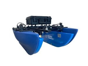
This project developed practical and open source methods to map potential restoration sites using a remotely operated survey vehicle. The longer-term aims are for those methods to be shared to other community groups. The Blue Boat will enable Seawilding to efficiently and effectively map bathymetry, seabed type, and habitat cover across large areas, significantly expanding our survey capacity beyond what is currently achievable using small snorkel survey teams.
This enhanced capability will allow snorkel surveys to be more strategically targeted, focusing specifically on assessing sediment suitability for restoration.
In 2025 SMEEF was able to provide a grant of £7000 to support this work using resources from the Nature Restoration Fund.